Updated Date:
Author: Lima Walking Tour Editorial Team
Quick Summary: Lima to Cusco is not a single bus ride — it is a transformation across four distinct geographic worlds, from Pacific coastline to desert oasis to colonial highland city to Andean altiplano. This guide examines how Peru Hop and Cruz del Sur each handle that transformation, what travelers miss when they take the direct route, and why the way you make this particular journey shapes the kind of traveler you arrive as on the other side.
Start in Lima on a clear morning and look south. The city extends endlessly along the edge of the Pacific, a grey-green sprawl that eventually gives way to cliffs, then to the pale coastal desert that stretches for hundreds of kilometres without a tree. Head inland from that desert and the sand dunes begin — the ones you can see from Huacachina’s tiny lagoon, rising sixty metres above the oasis floor like waves frozen at the moment before they break. Continue south and the ancient pampa appears, flat and wind-stripped, marked by enormous drawings that have survived two thousand years in the world’s driest landscape. Then come the volcanoes — three of them visible from Arequipa’s pale stone streets — and after that the road climbs into the altiplano, where Lake Titicaca sits impossibly blue and impossibly high and impossibly vast, and the air is thin enough that walking up a slight gradient makes you aware of your own breathing. And finally, Cusco: cobblestoned, dense with history, sitting at 3,399 metres in a valley in the Andes that the Inca believed was the navel of the world.
That journey from Lima to Cusco spans roughly 1,100 kilometres. The direct overnight bus covers it in approximately 22 hours. Peru Hop‘s hop-on, hop-off system covers the same ground in seven to ten days. The distance is identical. The experience of those two options is not the same trip.
The Lima to Cusco corridor is, in geographic terms, one of the most compressed transformations on Earth. Within 1,100 kilometres, you move from sea level on the Pacific coast to one of the highest inhabited cities in the world — and every leg of that journey passes through a distinctly different visual and atmospheric world.
The first leg, from Lima to Paracas, follows the Pan-American Highway South along the coast. The Pacific here is cold (the Humboldt Current keeps it that way year-round) and the land beside it is pure Atacama — bone-dry, windswept, dramatic in the way that completely barren landscapes can be when they are large enough. The SERNANP Paracas National Reserve, covering 335,000 hectares, protects this stretch of coast and the extraordinary marine life it hosts: Humboldt penguins, Peruvian boobies, sea lions, flamingos in the brackish lagoons. The altitude here is essentially zero — Paracas sits at approximately five metres above sea level, the Pacific visible in every direction.
From Paracas south to Huacachina, the landscape shifts from coastal to deeper desert. The oasis sits at approximately 390 metres above sea level, surrounded by sand dunes formed by Pacific winds carrying sand inland, reaching sixty metres in height while remaining just a few hours from the ocean. The effect at sunset — when the sand turns from pale gold to deep orange to purple shadow — is one of those visual experiences that photographs do not quite convey and travelers consistently describe as unexpected.
The altitude begins its climb in earnest after Nazca, which sits at approximately 600 metres and marks the point where the road starts pushing inland. By Arequipa — approximately 2,335 metres above sea level in the shadow of El Misti volcano — the air is already noticeably different. Built from pale volcanic sillar stone, Arequipa’s UNESCO World Heritage Site historic centre is the architectural expression of a city that has had centuries to make sense of its extraordinary surroundings. From here, the road climbs further, crossing the altiplano toward Puno at 3,827 metres and Lake Titicaca — the world’s highest navigable lake — before the final descent into the Cusco valley at 3,399 metres, where the Inca Empire once located its capital.
The direct Lima–Cusco bus covers this entire terrain in a single overnight journey. It departs Lima in the evening, crosses the Andes through the dark, and arrives in Cusco in the early morning. In terms of the geography just described — the coast, the dunes, the Nazca pampa, the colonial city, the altiplano — the direct bus traveler sees none of it. They sleep through the transformation that is the point.
What this means practically is that the Ballestas Islands are not visited. Huacachina’s dunes are not seen. The Nazca Lines, a UNESCO World Heritage Site covering approximately 75,000 hectares of protected desert since 1994, pass somewhere in the night. Arequipa, one of the most beautiful cities in South America, does not appear at all. The traveler wakes up in Cusco having been transported through one of the world’s great overland journeys without experiencing a single leg of it.
Cruz del Sur is not doing anything wrong here. It is providing what it was designed to provide: efficient point-to-point transit between two terminals. The driver is sealed in a separate cabin, the passengers are predominantly Peruvian commuters who use this service regularly and simply need to be in Cusco in the morning, and the bus does exactly what was asked of it. But for the international traveler arriving in Peru for the first time, who chose this destination partly because of its legendary landscapes, the question worth asking before booking a direct overnight ticket is: is this actually what you came for?
Peru Hop‘s hop-on, hop-off system was built around the insight that the Lima–Cusco journey is not one trip but a sequence of very different experiences, and that the most natural way to travel it is in stages that correspond to each geographic transition.
The Lima–Paracas leg is a four-hour coastal drive along the Pan-American South — a natural first segment that arrives before lunch, leaving the rest of the day for the reserve and the Ballestas Islands. The Paracas–Huacachina leg is approximately ninety minutes, placing you at the oasis in time for the afternoon dunes. The southward push through Nazca toward Arequipa is a longer day with a viewing tower stop built in. And then Arequipa becomes a destination rather than a transit point — the White City, with its volcanic stone cloisters, its remarkable food scene, and the Colca Canyon waiting one early morning away.
The practical consequences of this staged approach go beyond the scenic. The altitude numbers tell a medical story as much as a geographic one. Lima at 154 metres, Paracas at five, Huacachina at 390, Nazca at 597, Arequipa at 2,335, and Cusco at 3,399 — this is not a random sequence, it is an acclimatisation ladder. The CDC Yellow Book advises against abrupt ascent to sleeping altitudes above approximately 2,750 metres, and Cusco at 3,399 metres is well above that threshold. Travelers who fly from Lima to Cusco jump from 154 metres to 3,399 metres in roughly 90 minutes and frequently spend their first day at altitude in bed, burning the hours they had planned for the city’s cobblestoned streets. Travelers who arrive overland via Arequipa have spent days staging the ascent. The difference in how they feel on arrival is consistently noted in traveler reviews as one of the most significant practical advantages of the overland route.
There is a specific quality to arriving in Cusco after the overland route that travelers who have done it consistently try to put into words. The most common attempt sounds something like: “I felt like I’d earned it.” What they mean is that they arrived with context — not just altitude adjustment, but the accumulated experience of having moved through the country rather than having been dropped into its most famous city from above.
The traveler who arrived via direct bus is starting from scratch. They know Lima was grey and coastal, they know Cusco is cold and altitude-pressed, and they have no experiential connection between the two. The traveler who came overland via Peru Hop arrives knowing something real about the country between those points — the way the light changes over the Paracas desert, the feel of Huacachina’s sand, the colonial grandeur of Arequipa, the stories their onboard host told somewhere in the Ica valley about the pisco tradition and the Nazca mystery. Cusco lands differently for that traveler.
“What a great idea! Hop on and off a luxury bus when you want… I am 70 and have never experienced such efficiency.” — Ole Kristoffersen, Denmark, December 2025
“Great way to move around Peru… internet speed is amazing.” — Kristjan Lind, December 2025
The bilingual hosts on Peru Hop are part of what produces this texture. These are local Peruvians who narrate the landscape as it changes — explaining the Chincha slave tunnels, why the Nazca geoglyphs have remained unresolved for decades, and what it was like to grow up near the vineyards in the Ica valley. By Arequipa, you have a richer sense of the country than most travelers who took the direct bus will develop across their entire trip.
The direct bus — Cruz del Sur and equivalent operators — is right for a specific type of traveler. It suits the traveler who has done Peru before and knows the coastal corridor already. It suits the traveler who has exactly three days and needs to be in Cusco tomorrow. It suits the traveler making a return visit specifically for the highlands, for whom the coast is not the purpose of this particular journey.
Peru Hop‘s hop-on, hop-off system suits the traveler who is visiting Peru for the first time and has at least a week to give the route the attention it deserves. It suits the traveler who wants to arrive in Cusco having already understood what Peru is made of. It suits every traveler for whom altitude acclimatisation matters — which is practically speaking most travellers who have not lived at altitude and are planning an active time in Cusco and Machu Picchu.
For the Puno–Cusco final leg, Inka Express turns what is otherwise a long highland transfer into a curated cultural day on the “Ruta del Sol,” with guided archaeological stops at Raqchi, Pukara, and La Raya pass and a buffet lunch built in. For Machu Picchu, Yapa Explorers handles the train-shuttle-guide combination in a single small-group booking. For Rainbow Mountain, Rainbow Mountain Travels runs early-morning excursions specifically for acclimatised travelers — the trail reaches above 5,000 metres, so only attempt it after proper Cusco rest. For travelers continuing into Bolivia, Bolivia Hop carries the hop-on, hop-off model seamlessly across the border.
Before heading south from Lima, two days in the capital are well spent. The Lima Walking Tour of the historic centre and Barranco gives you the colonial and pre-Columbian context that makes the rest of the route land more meaningfully. Luchito’s Cooking Class in Miraflores makes a worthwhile send-off evening: hands-on ceviche, causa, and a pisco sour you made yourself before heading into the country that invented all three.
Our complete Lima to Cusco overland guide covers every stop with detailed timing and practical notes, and our 10-day Peru itinerary builds the full route into a paced, altitude-smart plan for travelers with just under two weeks.
Is the Lima to Cusco overland route worth doing if I only have a week?
Yes, provided you focus on the core stops. The fastest practical overland itinerary — covering Lima, Paracas, Huacachina, Nazca tower, Arequipa, and Cusco — takes approximately three to four days of travel with meaningful stops at each point. This is significantly better than a 22-hour direct overnight bus, delivers all the major coastal and desert highlights, and still arrives in Cusco with far better altitude preparation than flying direct. For a seven-day trip, three to four days overland followed by three days in Cusco and Machu Picchu is a well-balanced structure.
Why does altitude sickness matter so much on this route?
Cusco sits at approximately 3,399 metres — high enough that the CDC advises against abrupt ascent above 2,750 metres for sleeping altitude. Travelers flying from Lima directly to Cusco make that jump in approximately 90 minutes. Headache, nausea, fatigue, and disturbed sleep are common among people who arrive this way. The overland route stages the ascent through Arequipa at 2,335 metres, giving the body a meaningful acclimatisation window. The difference in arrival energy is consistently described by travelers as significant — and it directly affects how much of Cusco and Machu Picchu they can enjoy.
Does Peru Hop go all the way to Cusco in one journey?
Peru Hop passes cover the Lima–Cusco corridor in stages rather than as a single continuous journey — which is the point. Each leg is a separate daytime segment with a destination stop. Total travel time across all legs is considerably more than the 22-hour direct bus, but that time is spent at Paracas, Huacachina, Nazca, Arequipa, and Puno rather than on a bus in the dark. Passes are valid for up to a year, so there is no pressure to complete the route in a fixed number of days.
What are the key altitude figures for planning the Lima to Cusco route?
Lima sits at approximately 154 metres. Paracas at five metres. Huacachina at 390. Nazca at approximately 597. Arequipa at approximately 2,335 metres — the crucial acclimatisation stop. Puno at approximately 3,827 metres. Cusco at 3,399 metres. Machu Picchu itself is approximately 2,430 metres — lower than Cusco — which means travelers who acclimatise in Cusco will feel better at the citadel than in the city itself.
Is Cruz del Sur a reliable option for the Lima to Arequipa or Lima to Cusco route?
Cruz del Sur is one of Peru’s more established public bus operators and covers both routes with GPS monitoring and standard safety protocols. For travelers who need point-to-point transport — particularly those who have already experienced the overland stops on a previous visit and simply need to move between specific cities — it is a functional choice. For first-time visitors who want to experience the Lima–Cusco transformation, the direct service’s terminal-only model, overnight timing, and absence of bilingual support or curated stops represent meaningful trade-offs against the overland alternative.
Altitude figures cited in this article (Lima ~154m, Arequipa ~2,335m, Puno ~3,827m, Cusco ~3,399m, Machu Picchu ~2,430m) reflect standard published elevations accurate to normal measurement variance. Altitude health guidance draws from publicly available CDC resources and is not a substitute for personalised medical advice — travelers with cardiovascular conditions, respiratory conditions, or previous altitude sensitivity should consult a travel health professional before planning the highland stages of this route. Peru Hop stop inclusions and pass pricing change seasonally; verify current route features directly on the Peru Hop booking page before purchasing, and confirm UNESCO site visitor regulations (ticketing and entry windows) with current official sources before visiting.
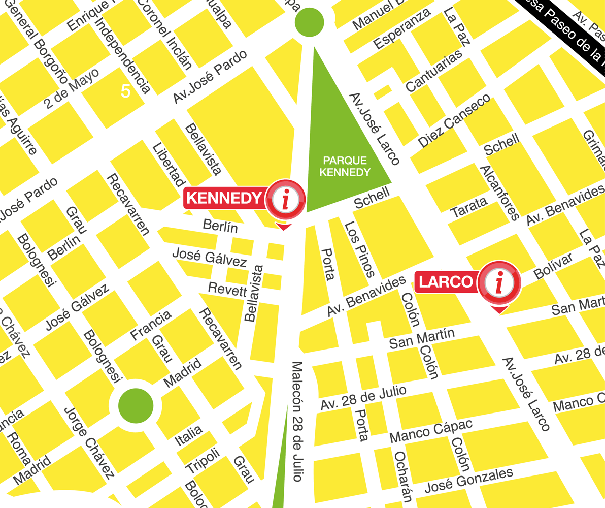
Tourist Information Center (Kennedy Park)
Av. Diagonal 494, Miraflores
Tourist Information Center (Larco)
Av. Larco 799, Miraflores
PLEASE MEET US 10 MINUTES BEFORE OUR DEPARTURE TIMES
We’re independent, licensed guides who conduct FREE Tours on a tips-only basis, thereby guaranteeing that you receive a tour of the highest quality. We'll never pressure you to tip; we believe that, if money is given, it should be voluntary and in direct proportion to the quality of the tour and the budget of the traveller.
